Coordinate system - elements
The five elements which define a coordinate system are:
• a transformation
• a projection
• an ellipsoid
• a geoid model
• a Country Specific Coordinate System model
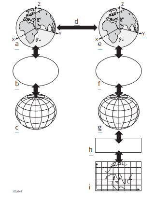
a WGS 1984 cartesian: X, Y, Z
b WGS 1984 ellipsoid
c WGS 1984 geodetic: Latitude, longitude, ellipsoidal height
d 7 parameter transformation: dX, dY, dZ, rx, ry, rz, scale
e Local cartesian: X, Y, Z
f Local ellipsoid
g Local geodetic: Latitude, longitude, ellipsoidal height
h Local projection
i Local grid: Easting, Northing, orthometric height
All these elements can be specified when creating a coordinate system.
CSCS model (*.ccg)
Description
Country Specific Coordinate System models
• are tables of correction values to convert coordinates directly from WGS 1984 to local grid without the need of transformation parameters.
• take the distortions of the mapping system into account.
• are an addition to an already defined coordinate system.
Types of CSCS models
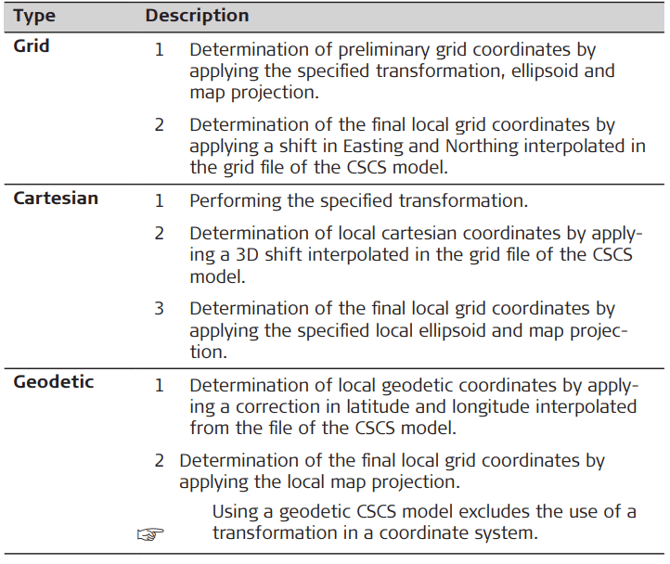
The correction values of a CSCS model can be applied at different stages in the coordinate conversion process. Depending on this stage, a CSCS model works differently. Three types of CSCS models are supported. Their conversion process is as explained in the following table. Any suitable geoid model can be combined with a geodetic CSCS model.